Profile
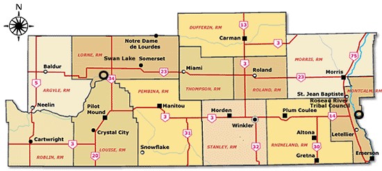
The Rural Municipality of Roland is located in the Pembina Valley Region of Manitoba. The R.M. of Roland lies approximately 100 kilometres southwest of Winnipeg, 40 kilometres north of the U.S. border. Within the R.M. of Roland are the Village of Roland and the Hamlet of Myrtle. Roland is located centrally between the larger urban centres of Carman to the north, Morris to the east, Winkler and Morden to the south. All major services are available nearby in these communities.
The population of approximately 1000 residents are predominantly rural. Economic activity in the R.M. has always been agriculturally based and continues to be so today. The rich fertile soil of the municipality supports a variety of crops and produces high product of quality and yields. Cereal grains, canola, corn, sunflowers and beans are just a few of the many crops grown in the area. Several small specialty operations have sprung up such as U-Pick Berry Farms and small market gardens. The business community is small but does provide most basic necessities. Some of the local services include a gas station, convenience store, restaurant and post office.
- Elevation - 860
- Latest Census Population (2016) - 1129
- Incorporated Municipality Type - Rural Municipality
- Date Municipality Incorporated - November 4, 1908
- Region - Pembina Valley
- Longitude - 97° 54' 40"
- Latitude - 49° 20' 8
- Land Area Sq. Km - 466.2
- Land Area Sq. Miles - 186.48
- Location: PTH #23, 100 km/63 miles SW of Winnipeg
Climate: Temperature (Seasonal Averages)
- January (winter season): -12°C 10.4°F
- April (spring season): -11°C 51.8°F
- July (summer season): 27°C 80.6°F
- October (autumn season): 12°C 53.6°F
Precipitation:
- Average rainfall per year: 399mm 15.96inches
- Average snowfall per year: 122mm 4.88inches
- Total Precipitation: 521mm 20.48inches
Average number of frost free days: 120